“If there is magic on this planet, it is contained in water.”
-
Loran Eiseley, The Immense Journey, 1957
Hydrology of the Watershed
Contributed by: Craig N. Kendall, Hydrologist, Flathead National Forest
Hydrology is the study of the movement, distribution, and quality of water; it includes all components of the hydrologic cycle on the earth and in the atmosphere. A practitioner of hydrology is a hydrologist and may work in a variety of related fields such as earth or environmental science, physical geography, geology, or civil and environmental engineering. Sub-disciplines of hydrology include hydrometeorology, surface water hydrology, hydrogeology, watershed science, forest hydrology, and water chemistry.
Surface Water
Surface water generally consists of water that we can see in the forms of snow, ice, rivers, streams, lakes, wetlands, and soil moisture. The Flathead Watershed is home to spectacular surface water features that are rich in social, cultural, and resource values. Flathead Lake, the three forks of the Flathead River, and the numerous glaciers, snowfields, and lakes are notable surface water features. The thousands of lakes, ponds, and wetlands in the Flathead Watershed are the direct result of recent glaciation that scoured the landscape and left behind deposits that now impound surface water.
Surface water in the Flathead Watershed is in constant motion. Water held as snowpack in the mountains during the winter months begins to melt in the spring causing small streams to rise. Annual peak flows in lower rivers typically occur in May and June (Figure 1.17). Peak stream flows occur in response to snowmelt by itself, snowmelt mixed with rain, or direct rain-on-snow. As the snow melts during the spring months, it recharges soil moisture and ground water. As lower hillslopes become saturated they begin to generate surface water flow that feeds headwater streams. In general, the residence time of water in hillslopes increases with distance away from the ridge tops. In other words, water lower on the hillslope and close to streams is “older” than the water stored in the soil closer to the ridge tops. Because of this residence time, some of the water we see in streams and rivers may have fallen on the watershed years or decades earlier. Hillslopes store water for months to years and then release it to streams in minutes or hours.
Most of the annual floods recorded at the USGS gaging stations around the Flathead Watershed have occurred in May, June, or early July. Extreme rain-on-snow events are more common on the eastern side of the watershed affecting Glacier National Park, and the Middle and South Forks of the Flathead River Drainages.
 |
Figure 1.17: Average daily discharge of major rivers in the Flathead Watershed. |
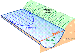
| How is discharge measured in a river? Discharge is typically expressed in cubic feet per second (ft3/s) and represents the actual volume of water flowing past a given point. In general, discharge (Q) is equal to the product of the average depth (d), width (w), and velocity (v) at a cross-section of the river: Q = w x d x v Usually, the cross-section is divided into sections or “cells” where depth, width, and velocity measurements are collected to calculate Q for each cell. Then the cells are added up to estimate the total discharge. Once several measurements are taken at a given site, they are correlated with the water surface elevation or “stage” of the river. Then measurements of stage can be recorded by specialized instruments at a gaging station to provide continuous estimates of discharge. |
 |
| Figure 1.18: How to measure water discharge in a stream. Source: Dr. Karen A. Lemke |
Ground Water
Ground water is found beneath the surface in the soil and rock. Excess soil moisture is pulled downward by gravity to a point where the spaces in the soil and rock become saturated. The top of this zone of saturation is called the water table. Ground water typically moves very slowly in deep aquifers with little porosity, or it may move rapidly through highly porous material close to the surface.
Average annual surface water discharge at the USGS gaging station on the Flathead River at Columbia Falls is approximately 7 million acre-feet (8.6 billion m3). Of this average annual discharge, about 3.6 million acre-feet (4.4 billion m3) are attributed to ground water discharge. The baseflow of a river or stream is the portion of total discharge that is supported by groundwater. The groundwater component sustains streamflow between periods of rain or snowmelt. For example, the baseflow for the Flathead River at Columbia Falls (Figure 1.5) might be estimated to be approximately 5,000 cubic feet (142 m3) per second.
| Deposit | Description | Hydraulic Conductivity |
| Modern River Deposits | Well sorted cobble, gravel, sand, silt, and clay deposited by rivers and streams | Moderate - High |
| Glacial Lake Deposits | Silt and clay deposited by glacial lakes | Low |
| Glacial Till | Poorly sorted mixture of clay, sand, gravels, and boulders deposited by glaciers | Low |
| Glacial Outwash | Well sorted and stratified gravel, sand, and silt deposited by glacial meltwater | Moderate – High |
| Valley Fill | Undifferentiated gravel, sand, silt, clay, and shale | Low-High |
| Bedrock | Siltstones, mudstones, and limestone | Low |
| Figure 1.19: Glacial deposits and fill. Source: C. Kendall, Flathead National Forest. | ||
An understanding of the groundwater resources of the Flathead Watershed requires an understanding of landscape form and geologic material. Much of the groundwater resource is located in shallow and deep aquifers of the Flathead Valley and the major river valleys surrounding it. The Flathead Valley and surrounding river valleys have a complex array of alluvial and glacial deposits that store groundwater (Figure 1.19). The depth to bedrock in the valley ranges from just a few feet to over 500 (1 to over 150 m).
Ground water flow in the valley is generally from north to south. The vertical distance to the water table is highly variable. It may range from 2-3 (.6 - .9 m) near the Flathead River up to a few hundred feet (91 m). Water tables fluctuate seasonally as well, with the lowest depths usually occurring in January and February. The glacial deposits and older valley fill shown in Figure 1.19 hold the primary sources of groundwater in the Flathead Watershed. Almost all the municipal, domestic, industrial, and irrigation water use in the Flathead Valley comes from groundwater sources. The City of Whitefish is a notable exception using surface water from a nearby stream and from Whitefish Lake. Continued population growth and associated ground water use have raised concerns about the long-term sustainability of groundwater resources.
Groundwater and Surface Water Interactions
Groundwater and surface water are intimately connected. Under most circumstances streams are fed by groundwater in the Flathead Watershed. These types of streams are called effluent streams or gaining streams. Streams that loose water and feed the groundwater system are called influent streams, or losing streams.
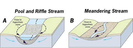
Near stream channels, there are complex ground water and surface water interactions and flow patterns. This is due to meanders in the stream, changes in stream gradient, changes in streambed sediments, or changes in geologic features. The transition zone between groundwater and surface water in a stream is called the hyporheic zone, and it is an ecologically important component of streams and rivers providing unique habitats for aquatic insects particularly during dry periods, and may provide protection for them during flood events. Migratory bull trout have been known to spawn in areas where groundwater upwells into streams.
 |
| Figure 1.20: Hyporheic zone. Source: USGS Circular 1139 Surface-water exchange with ground water in the hyporheic zone is associated with abrupt changes in streambed slope (A) and with stream meanders (B). |
The wide valley bottoms and extensive floodplains of the Flathead Watershed provide the conditions for widespread hyporheic exchange. The Nyack floodplain of the Middle Fork Flathead River has long been recognized for its high degree of hyporheic exchange, marked by upwelling of groundwater and lateral movement of surface water into the shallow alluvial aquifer. This area and many others along the Flathead River system support unique aquatic ecosystems that are greatly influenced by hyporheic exchange.

