BIODIVERSITY
“It is not the strongest of the species that survives, nor the most intelligent that survives.
It is the one that is the most adaptable to change.” - Charles Darwin
Biodiversity Explained
First used by conservationist and ecologist Raymond Dasmann in his 1968 book A Different Kind of Country, the term biodiversity was not widely adopted until the 1980s. Biodiversity is a combination of the words “biological diversity” and refers to the variation of living organisms. There are three components to biodiversity: genetic diversity (variation of genes within a species), species diversity (the number of different species within an ecosystem), and ecosystem diversity (the variety and complexity of a biological community including trophic levels and ecological processes).
Biodiversity in the Watershed Today
The Flathead Watershed is rich in terrestrial and aquatic wildlife habitat. Our forests, meadows, lakes, rivers, streams, wetlands, and riparian corridors are home to a diverse community of large carnivores, ungulates (hoofed animals), small mammals, amphibians, reptiles, birds, fish, and aquatic and land insects. Citizens and visitors marvel at the endless prairie panoramas, towering mountains, extensive waterways, and the wildlife that inhabit them. Grizzly and black bears thrive in dense forests filled with huckleberries. Deer and elk forage on plentiful grasses and shrubs. Birds of prey dive into the rich undergrowth for small mammals. And fish spawn in clear, cold rivers and streams that meander through miles of mountains, meadows, and fields of over 1,000 wildflower species.
The Flathead Watershed is one of the largest, most biologically intact ecosystems in North America with over 400 terrestrial wildlife species, including 11 amphibians, 11 reptiles, 319 birds, and 71 mammals. Forty-six species of fish (including 23 natives) also make the Flathead Watershed their home. The watershed’s mostly public lands are managed by federal, state, and tribal agencies. National forests, national parks, federal wilderness areas, research natural areas, and rivers with “Wild and Scenic” designation provide relatively undisturbed wildlife habitat and critical wildlife migration corridors (routes connecting otherwise isolated plant and animal populations) throughout the watershed. These pathways include a wide variety of habitats so that species at either end can safely traverse them. As human development continues to push further into wild areas, these habitat-linking corridors will become increasingly important.
Historical View
 |
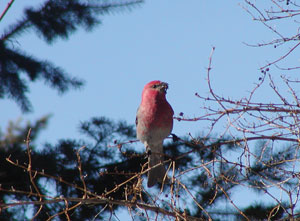
| Figure 2.35: Red Crossbill. Source: Lori Curtis |
Mapping the Land
From wide open prairies to dense forests, plant life varies greatly in the Flathead Watershed. Plant distribution is determined by geologic formations, and by moisture and temperature as seen in the dense forests of wetter ecosystems and the grassy plains of drier ecosystems. Plant distribution is also affected by altitude, as temperatures cool with increasing elevation. The U.S. Forest Service adopted a classification and mapping system (ECOMAP) to help standardize ecosystem management in national forests, grasslands, and research programs.
 |
| Figure 2.36: Ecoregions of Montana. Source: A. Woods, J. Omernik, J. Nesser, J. Sheldon, J. Comstock, S. Azevdo |
The system hierarchically classifies the earth into ecological units that take into account climate, geography, soils, air, water, and the plant and animal communities that an area can support. The hierarchy divides the earth into successively smaller units defined as Domains, Divisions, Provinces, and Sections. The maps include current available knowledge and provide a platform from which managers can further study and communicate about management activities in specific regions. These large maps, loaded with detailed information, are strikingly beautiful. The Montana portion of the Flathead Watershed is part of the Northern Rocky Mountain Forest-Steppe-Coniferous Forest-Alpine Meadow Province and can be found on the Ecoregions of Montana map. This province includes 38,100 square miles (98,700 km2) of land in western Montana, northern Idaho, and eastern Washington.
The British Columbia Ecoregion classification system similarly divides the province into Ecodomains, Ecodivisions, Ecoprovinces, Ecoregions, and Ecosections. Adopted by the Wildlife Branch of the B.C. Ministry of the Environment in 1985, this classification system provides a systematic view of small scale ecological relationships based on macroclimatic processes (atmospheric and geographic factors of climate) and physiography (physical geography). It takes into account terrestrial and marine environmental and climatic zones.
 |
| Figure 2.37: Ecoregions of British Columbia. Source: B.C. Ministry of the Environment |
Ecodomains and Ecodivisions, like their U.S. Domain and Division counterparts, help to place British Columbia’s ecology in a global context. Ecoprovinces, Ecoregions, and Ecosections describe climate, physiography, and vegetation and wildlife potential. At the most granular level, terrestrial and marine environments are further subdivided into biogeoclimatic criteria that provide important information for wildlife and fisheries managers.


