Land Ownership
“I think having land and not ruining it is the most beautiful art that anybody could ever want to own.” - Andy Warhol, American painter, printmaker, & filmmaker 1928-1987
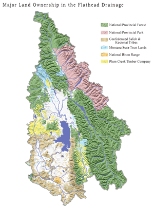 |
| (click to enlarge) Figure 6.1: Major Land Ownership in the Flathead Watershed. Source: Mobile LoGIStics Mapping, 2010. In 2010, the Flathead National Forest acquired 70 square miles (181 km2) in the Swan Valley from Plum Creek Timber Company. This land exchange eliminated most of the checkerboard ownership pattern shown on this map. |
The idea of land ownership came to the Flathead Watershed with European settlement. The early Native American inhabitants did not claim ownership nor did they divide the land into parcels. Today, a majority of watershed land is publicly owned and managed by U.S. and Canadian federal and state governments, and by large private landowners (Fig. 6.1).
Flathead Indian Reservation
The Flathead Indian Reservation encompasses 1.317 million acres (533,395 hectares) in the Mission, Little Bitterroot, and Lower Flathead River Valleys. The Bitterroot Salish, Pend d’Oreille and one band of Kootenai, now known as the Confederated Salish and Kootenai Tribes (CSKT), reserved the Flathead Reservation, a portion of their vast aboriginal territories, for their exclusive use through the Hellgate Treaty of 1855.
The Reservation includes the southern half of Flathead Lake and approximately 68 miles (109 km) of the lower Flathead River and its tributary streams. The CSKT manage Reservation land and natural resources through a Comprehensive Resources Plan (1996), and multiple resource and area-specific plans. The Tribal Historic Preservation Office and two culture committees work to protect and perpetuate cultural resources.
 |
Timber covers about 35% of the Reservation. Ninety-two thousand acres (37,231 hectares) are managed as the Mission Mountains Tribal Wilderness, the first wilderness in the nation to be formally reserved and protected from development by a tribe. The northwest and southeast portions of the Reservation, including the lands surrounding the South Fork of the Jocko River, have been designated as Primitive Areas for Tribal member use only.
There are hundreds of allotments owned in whole or in part by individuals and the Tribes. In 1910, over the objection of Tribal leaders, the U.S. government opened up land on the Reservation to homesteading. After efforts to buy back Reservation lands, the Tribes now own about 60% of the Reservation, making them the single largest landowner in Lake County.
The Tribes are also the majority landowner in the portions of Flathead, Missoula and Sanders Counties that intersect with the Reservation, owning 82%, 90% and 65% respectively. The federal government holds title to individually-owned allotments, and most Tribally owned lands in trust for the owners, and has a fiduciary responsibility to assist the Tribes with management of Reservation resources. The remaining land is held in federal, state, or fee ownership.
CSKT members use and manage land for a variety of purposes including farming, grazing, forestry, water storage and irrigation, power generation and distribution, housing, transportation, commercial and manufacturing operations, gravel mining, wildlife and fisheries habitat preservation, recreation, wilderness and open-space preservation, and other cultural purposes.
Confederated Salish & Kootenai Tribes
http://www.cskt.org
406.675.2700
U.S. Forest Service – Flathead National Forest
 |
 |
The Flathead National Forest Service manages over 2.4 million acres (971,246 hectares)—about 45% of the lands within the Flathead Watershed—which includes three Wilderness Areas and lands in the North, Middle and South Forks of the Flathead, Swan and Stillwater drainages. In total, they administer the largest amount of public lands in the watershed. The Flathead National Forest together with the smaller acreages of the Kootenai and Lolo National Forests comprise 55% of the acreage in Flathead County plus some small acreage in Lake County.
Congress designated over one million acres (432,987 hectares) of the Flathead National Forest as part of the National Wilderness Preservation System. As part of this system, the Bob Marshall, Great Bear, and Mission Mountains Wilderness Areas comprise about 45% of the total land base. Roads, timber harvest, and motorized travel are not permitted in these areas.
The Flathead Wild & Scenic River, Jewel Basin Hiking Area, and Coram Experimental Forest are all designated as special management areas. The remaining 1,300,000 acres (526,091 hectares) of non-wilderness areas have roads and are open to timber harvest, recreation-based motorized travel, and other activities restricted in wilderness areas.
U.S. Forest Service
http://www.fs.fed.us
800.832.1355Flathead National Forest Service
http://www.fusda.gov/flathead
406.758.5204
U.S. National Wildlife Refuges

The U.S. Department of the Interior Fish & Wildlife Service (USFWS) manages or co-manages the National Wildlife Refuges in the watershed, including: the 18,526-acre (7410-hectare) National Bison Range, the 2,500-acre (960-hectare) Pablo National Wildlife Refuge, the 2065-acre (825-hectare) Ninepipe National Refuge, the 1,568-acre (627-hectare) Swan River Refuge, and the nine Waterfowl Production Areas (WPAs) in Lake County and five WPAs in Flathead County totaling 5,739 acres (2,295 hectares). These U.S. Fish and Wildlife Service-managed WPAs are part of the National Wildlife Refuge System. Hunting and fishing are allowed in WPAs, but no recreational activities (unless specifically authorized) are allowed in National Wildlife Refuges.
http://www.fws.gov/refuges
Parks Canada - Waterton Lakes National Park
Waterton Lakes National Park includes 129,920 acres (52,617 hectares) of land managed by Parks Canada, a federal agency that is part of the Department of Canadian Heritage. The park is managed for preservation of the park’s ecological integrity while encouraging recreation and education. All of the land within the park is government owned with all uses leased from the government. The park borders British Columbia to the west and Glacier National Park and Montana to the south.
http://www.pc.gc.ca/eng/index.aspx
National Park Service - Glacier National Park
Glacier National Park includes 1 million acres (400,000 hectares) and is managed by the U.S. Department of the Interior National Park Service. Approximately 635,214 acres (257,061 hectares) of Glacier National Park’s 1,008,306 acres (408,047 hectares) are in Flathead County (19% of Flathead County’s land mass), and the  remaining land is in Glacier County. It is managed for preservation of its natural values and recreation. Most of the park is managed as wilderness, except in villages and along roads. There are about 418 acres (169 hectares) of privately owned parcels and residences within the park boundaries all of which were privately owned prior to the establishment of the park. 2010 is the centennial—the 100th anniversary—of Glacier National Park.
http://www.nps.gov/glac/index.htm. 406.888.7800
 |
 |
 |
|
 |
|
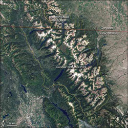
| Figure 6.2: Waterton-Glacier International Peace Park. Source: NASA | |
Waterton-Glacier International Peace Park Together, Waterton Lakes National Park and Glacier National Park form the 1802 square mile (4,667 km2 Waterton-Glacier International Peace Park. The Peace Park was established by the governments of Canada and the U.S. to commemorate the peace and goodwill between the two countries and their shared cultural and ecological heritage. The UNESCO-named World Heritage Site recognizes the Peace Park for its “distinctive climate, physiographic setting, mountain/prairie interface and tri-ocean hydrographic divide as well as its scenic value and cultural importance.” Many significant research activities and conservation programs take place in this ecologically and culturally important transboundary region.
British Columbia Provincial Parks
Of the 5.8 million acres (2,347,176 hectares) of land in the Flathead Watershed, 7% or 389,227 acres (157,515 hectares) are in British Columbia, mostly managed by the B.C. Ministry of Forests. This public land is managed under the Canadian Forest Practices Code for multiple use including timber, mining, grazing, wildlife, watershed protection, and recreation. There are no national parks in British Columbia, but the three provincial parks are managed similarly to national parks to preserve natural diversity and provide recreation.
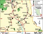 |
| (click to enlarge) Figure 6.3: Akamina-Kishinena Provincial Park. Source: BC Ministry of Forests |
The Akamina-Kishinena Provincial Park is located at the southeast corner of the province at the northernmost portion of the Flathead Watershed abutting Waterton Lakes and Glacier National Parks. The 26,977 acres (10,922 hectares)—almost all above treeline—is managed for backcountry recreation and wildlife habitat. The trails and passes of this park were established and used for many years by the Ktunaxa aboriginal people who traveled through South Kootenay Pass to reach the plains for buffalo hunting and trading. Remnants of oil rigs that were first brought into the area in 1905 remain visible, but no economically significant wells were ever drilled. Attempts were made at other mining activities, but those too failed to be productive. B.C. Ministry of Forests, http://www.gov.bc.ca/for. 604.660.2421
Montana State Parks and Lands
There are several Montana State Parks in the Flathead Watershed, including Flathead Lake, Lake Mary Ronan, Whitefish Lake, Placid Lake, and Salmon Lake. Flathead Lake is the largest with six individual parks within the Flathead Lake Park System. An issue commonly voiced by citizens is the lack of public access to Flathead Lake. There are 68 federally owned and 20 locally owned public access  points. Of these 88 lake access points, 45 are located on the west shore of the lake and 30 on the east shore. Only nine have been fully developed, and 28 partially developed. Twenty-eight are not likely developable and 14 are possibly developable. Private interests at one time were adamantly opposed to the development of public access to Flathead Lake. This led to an agreement that Montana Fish, Wildlife & Parks would not develop lands in competition with private camp grounds in the Flathead Watershed.
The Montana Department of Fish, Wildlife and Parks (MFWP) also manage numerous public fishing access sites at lakes, reservoirs, and rivers, and they manage lands for recreation and wildlife habitat. MFWP is responsible for the state’s Wildlife Management Areas (WMAs) where many ungulate species find important protected habitat.
Montana Fish, Wildlife & Parks
http://fwp.mt.gov/parks
406.444.2535
 The Montana Department of Natural Resources and Conservation (DNRC) Trust Lands Division manages 239,600 acres (91,422 hectares) of state land to generate revenue to support education and other public institutions through timber harvest, grazing, recreational use, commercial leases, and cabin site leases. The DNRC mission is to help ensure that Montana’s land and water resources provide benefits for present and future generations. It is responsible for promoting the stewardship of Montana’s water, soil, forest, and rangeland resources; and for regulating forest practices and oil and gas exploration and production. In the past several years, the agency has generated over $400 million for Montana school children through management of state lands.
Montana Department of Natural Resources and Conservation
http://www.dnrc.mt.gov
406.751.2240
County Parks
Lake County recreational opportunities are available in various cities and towns including seven developed parks and sports facilities, and 51 undeveloped parcels of parkland. The City of Polson has 173 acres (70 hectares) of parkland including a baseball and soccer complex, fairgrounds, several lakefront parks, and several acres that are undeveloped. Polson operates a 27-hole municipal golf course. Ronan has a city park with a picnic area, baseball and softball fields, and a privately-owned golf course. St. Ignatius has three parks: Elders Park, which is tribally owned, Memorial Park, and Taelman Park.
The Flathead Department of Parks and Recreation maintains 37 park and recreation facilities and one cemetery, totaling 383 acres (155 hectares). Land-based parks include many multiple use trails, 20 ball fields, one volleyball court, four basketball courts, and multi-purpose fields: most offer picnic areas and playgrounds. There are 14 water based parks covering 163 acres (66 hectares) offering lake and river access via docks, boat ramps, and fishing sites. There are also 123 acres (50 hectares) of special use facilities dedicated to single use recreational activities or limited populations.
Flathead County Parks
http://flathead.mt.gov/parks_rec
Lake County
http://www.lakecounty-mt.org
Private Land
Timber
A substantial portion of private land in the watershed is used for timber production. Plum Creek Timber Company is the largest private landowner in the Flathead Watershed with 256,000 acres (103,600 hectares) and is one of the largest employers as well. It is also the biggest private landowner in the state of Montana with 1.45 million acres (580,000 hectares). The company is the largest private owner of habitat for “threatened” grizzly bear and bull trout in the U.S. Plum Creek prides itself on its land stewardship through three programs, the Sustainable Forestry Initiative, Montana Forestry Best Management Practices, and the Native Fish Habitat Conservation Plan. The company has interests in forest products and property development.
F. H. Stoltze Land and Lumber Company has about 38,000 acres (15,378 hectares) of forestland and a family-owned sawmill in the watershed. It is the oldest family-owned lumber company in Montana. Its origins go back to the 1900s when F. H. Stoltze contracted with the Great Northern Railway to provide materials for their expansion. Montana Forest Products is also a family-owned timberland management company with about 8,000 acres (3,237 hectares) of land. Other 10- to 100-acre (4 to 40 hectare) parcels of privately owned timberland are certified through sustainable forest management programs. Private forest lands provide wildlife habitat and watershed protection, and recreational opportunities as many of the landowners generously allow public access to their land.
F. H. Stoltze Land & Lumber
http://www.stoltzelumber.com or 406.892.7000
Montana Forest Products
406.755.6432
Plum Creek Timber Company
http://www.plumcreek.com or 800.858.5347
Residential
Residential development is the most rapidly growing land use in the Flathead Watershed. The conversion of agricultural and timber lands to residential developments is creating some of the greatest growth challenges for Flathead and Lake Counties. For growth to be successful, residential development density must be compatible with existing infrastructure, services, and local character. Roads—one of the essential components of infrastructure and services—have capacities which, if exceeded, can put public safety at risk. The likelihood of tragedy increases when emergency services such as fire, ambulance, and law enforcement are unable to respond quickly.
Several natural conditions must also be considered when planning higher density residential development. Development in areas with steep slopes can result in rockslides, mudslides, avalanches, and severe erosion. Development in 100-year and 500-year floodplains may avoid floods for many years, but they will flood again, and taxpayers historically have carried the burden of flood recovery. Access to common services and goods in rural areas helps mitigate other issues such as traffic and remoteness. Local coffee shops, restaurants, libraries, barber shops and hair salons help lessen long distance trips and traffic, and serve as gathering places for community residents.
One of the most important—and often controversial—considerations in residential land ownership and development is the preservation of the local character and identity in the many rural areas of the watershed. Many things make up that character including wildlife sightings, country roads, rural cafés, an agrarian lifestyle, and low density residential development. The wide-open spaces, quiet neighborhoods, scenic views, and dark night skies are also commonly associated with rural communities. Developers who include open space in their development designs increase the chances of maintaining the feeling of rural Montana.
Confederated Salish & Kootenai Tribes Land Use & Development Planning
http://www.cskt.org/tr/tld_landuse.htm
406.675.2700
Flathead County Planning & Zoning
http://flathead.mt.gov/planning_zoning
406.751.8200
Lake County Planning Department
http://www.lakecounty-mt.org/planning/index.html
406.883.7235
“Conservation is a state of harmony between men and land.” - Aldo Leopold
| Conservation & Conservation Easements Several private organizations conserve land in and around the Flathead Watershed, including the Nature Conservancy in the U.S. and Canada, the Montana Land Reliance, the Trust for Public Land, and our local Flathead Land Trust. The Nature Conservancy owns some lands outright for conservation, but also works to put conservation easements in place. Private landowners who recognize and want to preserve the ecological value of the land while maintaining their ability to farm, graze, or live on their land will often turn to conservation easements. |
Resources |
| Flathead Land Trust http://www.flatheadlandtrust.org 406.752.8293 |
|
| Montana Land Reliance http://www.mtlandreliance.org 406.837.2178 |
|
| The Nature Conservancy Montana http://www.nature.org/wherewework/northamerica /states/montana 406.543.6681 |
|
| The Nature Conservancy Canada http://www.natureconservancy.ca 800.465.0029 |

