Temperature & Precipitation
The most common measures of climate are temperature and precipitation. Average temperatures vary greatly with topography throughout the Flathead Watershed, however winter temperatures range from -20°F (-28°C) up to 32°F (0°C). Spring and early summer are partly cloudy and offer rain interspersed with occasional dry, warm days. Summer temperatures range from the 70°Fs (21°C’s) to the high 90F’s (30°Cs) with generally clear skies punctuated by afternoon thunderstorms. Occasional periods of even hotter temperatures occur in summer. In the later part of summer, it is not uncommon to see a 45°F (7°C) transition from a 75°F (24°C) day to a 30°F (-1°C) night. This explains the constant reminders to “dress in layers.” Fall brings moderate temperatures and a mixture of both clear and cloudy skies. Climatic changes often follow elevation changes in the watershed, though not always exactly as expected. While higher elevations are typically colder and valleys are typically warmer, it is not unusual to have a wintertime inversion that traps cold air in the valleys while the high altitude mountaintops enjoy the warmth of sunshine.
Temperature is influenced by Flathead Lake and the hundreds of other bodies of water throughout the watershed. The surface water of smaller lakes, rivers, streams, and sloughs limit temperature extremes until they freeze in winter. In particular, Somers and Polson enjoy milder weather because Flathead Lake is so large that it rarely freezes over. The amount of sunlight that reaches the land also varies throughout the watershed. North-facing slopes are exposed to far less sunshine than south-facing slopes, leading to cooler temperatures and a shorter growing season. The cool temperatures slow the melting of snow, allowing absorption by soil and supporting a greater variety and density of vegetation.
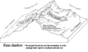
Precipitation varies significantly with the topography of the Flathead Watershed region. For instance, the Camas Prairie in the Flathead Indian Reservation is in the “rain shadow” of the Cabinet Mountains and is one of the driest parts of the watershed and Montana with approximately 12 inches (30.5 cm) of precipitation annually. The North Fork of the Flathead in British Columbia receives less than 20 inches (51 cm), and West Glacier receives as much as 30 inches (76 cm). Precipitation also increases with elevation. Twelve to 30 inches (30.5 to 76 cm) of precipitation falls annually in the lower valleys, 80 inches (203 cm) falls in the Whitefish Range, and as much as 122 inches (301 cm) falls in Glacier National Park. The highest annual precipitation ever recorded in the park was 150” (381 cm). The Whitefish Range also creates rain shadow conditions where the western side receives most of the rainfall, supporting rich and diverse forest growth while the dry, sheltered eastern slopes support only grasses, sagebrush, and pine trees.
 |
| Figure 2.16: Rain shadow. Source: Todd Berget |
An average of about 70% of the watershed’s precipitation falls in winter as snow, while summers tend to experience dry conditions. June is typically the wettest month. It is important to remember that snow can fall in the watershed any month of the year! The mountainous areas such as Glacier and Waterton Lakes National Parks, the Whitefish, Swan, and Mission Ranges experience the pile up of very deep snow throughout the winters. The quantity of snow and its annual runoff are vital for providing agricultural irrigation, feeding hydropower equipment, establishing forest fire patterns, and determining what plants and animals inhabit an area, as well as when and where fish will spawn.
 |
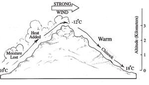
| Figure 2.17: Chinook wind formation. Source: Todd Berget |
The Chinook winds are yet another climatic characteristic found just beyond the Flathead Watershed on the east side of the Continental Divide. Chinooks blow where prevailing winds meet mountain ranges perpendicular to their path. The Chinook is a robust wind that warms and dries as it descends the lee (away from the wind) side of a mountain. Intense Chinook winds typically blow up to 60 miles (100 km) per hour. Waterton National Park has a high frequency of Chinooks contributing to its warmth in winter. In this northern tip of the watershed, Chinook winds can gain hurricane force of 75 miles (120 km) per hour. The warm winds melt and drive the snow sometimes transforming a deep snowfield into an exposed field of forageable grasses. These winds make critical nutrient-filled food available to grazing species during the colder winter months. There is much folklore and native legend surrounding the word “Chinook, ” but it is known to be the name of an early people who lived near the ocean along the Columbia River. We see only slight affects from Chinooks in the watershed.
Water Towers
Mountain regions in the Flathead Watershed and throughout the world provide a critical function as “water towers,” storing, controlling, and releasing water for domestic, agricultural, and industrial uses downstream. These essential sources of water are particularly important in drier regions where seasonal water deficiency is common. In the western United States, humans depend on mountain resources for 85% of their water.
Mountains obstruct incoming air masses, forcing the air to rise and cool, producing precipitation. This precipitation, along with cold temperatures and low evaporation in the mountains maintains a positive water balance. The valleys below receive less precipitation, are warmer and have higher evaporation, creating a negative water balance. The rivers, streams, and aquifers that flow under the influence of gravity from the mountains to the valleys work to adjust this imbalance. As glaciers melt, the amount and flow of water changes and will have a variety of impacts on the people, wildlife, and landscapes downstream that depend on this water.
Human development and alterations in mountain regions can damage these critical water tower regions. Increased soil erosion, changes in surface runoff, and excessive sedimentation of rivers and streams all affect the quantity and quality of water available for humans, animals, fisheries, and plants downstream. As the Flathead Watershed community grows, so does the demand for water, putting additional pressure on the natural system and on the management and distribution of the water it generates.

