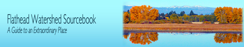
The Flathead Watershed
 |
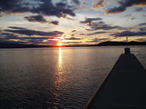
| click to enlarge |
| Figure 1.2: Flathead Watershed. Source: Mobile LoGIStics Mapping. |
The Flathead Watershed is a unique and beautiful place, rich in natural and cultural history. Magnificent glaciated rugged mountains rise above stunning valleys, lakes, wetlands, and floodplains that were cut and shaped by fantastic geologic activity. Hundreds of millions of years in the making, the Flathead Watershed is now a beautiful and complex patchwork of productive farms and ranches, spectacular wilderness, and vibrant cities. The Flathead Watershed (Figure 1.2) includes all the land that drains into the Flathead River and Flathead Lake and beyond the lake to the confluence of the Flathead and Clark Fork Rivers. The area begins across the Canada-U.S. border in the north, reaching down to the Clark Fork drainage in the south, and extends from the Salish Range in the northwest to the Continental Divide in the east including many smaller watersheds, lakes, and drainages.
From the pristine headwaters in Glacier National Park and the Bob Marshall Wilderness water flows through nearly six million acres (over two million hectares) of forests, farms, and cities. The waters of the Flathead, Stillwater, Swan, and Whitefish rivers all unite and join Flathead Lake, the largest natural freshwater lake west of the Mississippi River. The North, Middle, and South Forks of the Flathead River contribute approximately 80% of the water entering Flathead Lake. The river serves as the headwaters of the Columbia River and is the largest tributary of the Clark Fork River
.
The Whitefish River and Stillwater River together drain the northwest part of the watershed, joining the upper Flathead River just below Kalispell. The North, Middle, and South Forks of the Flathead River join together upstream of Columbia Falls, forming the upper Flathead River system. Together with the Swan River, they drain the eastern portion of the watershed and serve as the two central tributaries to Flathead Lake, emptying into the northeast portion of the lake. At the lake’s outlet, located at the southwest portion of the lake, the lower Flathead River flows 72 miles (116 km) to where it joins the Clark Fork River.
- Peter Steinhart, 1986
Home to several threatened and endangered species, the Flathead Watershed has the largest grizzly bear population in the interior of North America, as well as populations of black bear, deer, elk, bighorn sheep, mountain goat, lynx, bobcat, grey wolf, wolverines, and a host of small mammals. Wild turkeys, grouse, bald eagles, peregrine falcons, hawks, owls, jays, chickadees, nuthatches, and numerous other birds make the Flathead Watershed their home. The stretch of the Flathead River between Kalispell and Flathead Lake has one of the highest populations of osprey nests in Montana, and the watershed serves as an important bird migration corridor. Native bull trout and westslope cutthroat trout spawn in the clear, icy tributaries to Flathead Lake. The Flathead Watershed is also home to more than 300 species of aquatic insects, including 105 different stonefly species – one-fourth of all stonefly species in North America.
- Pindar, Olympian Odes, C. 522-C. 438 B.C.